Thank you for supporting this site ❤️
Make a donation
Make a donation
Gear up for your next adventure:
As an Amazon Associate, this site earns from qualifying purchases at no extra cost to you.
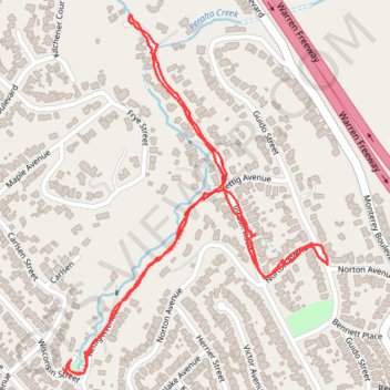
Peralta Creek / Rettig Canyon Walk
Oakland Walking
- Distance: 1.8 mi
- Elevation gain: 253 ft
- Maximum elevation: 446 ft
- Elevation loss: 262 ft
- Minimum elevation: 269 ft
- Moving time: 41 m 10 s
- Moving speed: 2.6 mph
- Maximum speed: 6.3 mph
- Total time: 44 m 27 s
- Global speed: 2.4 mph
Interactive trail map
Thank you for supporting this site ❤️
Make a donation
Make a donation
Gear up for your next adventure:
As an Amazon Associate, this site earns from qualifying purchases at no extra cost to you.
Trail profile
- Distance: 1.8 mi
- Elevation gain: 253 ft
- Maximum elevation: 446 ft
- Elevation loss: 262 ft
- Minimum elevation: 269 ft
- Moving time: 41 m 10 s
- Moving speed: 2.6 mph
- Maximum speed: 6.3 mph
- Total time: 44 m 27 s
- Global speed: 2.4 mph
Thank you for supporting this site ❤️
Make a donation
Make a donation
Gear up for your next adventure:
As an Amazon Associate, this site earns from qualifying purchases at no extra cost to you.
About this trail
Name: Peralta Creek / Rettig Canyon Walk trail, distance, elevation, map, profile, GPS track
Start: 4101, Rettig Place, Oakland, Alameda County, California, 94602, United States (37.79954 -122.19792)
Coordinates: 37.79943 -122.19792 37.80610 -122.19173
Topography: Oakland topographic map, elevation, terrain
Thank you for supporting this site ❤️
Make a donation
Make a donation
Gear up for your next adventure:
As an Amazon Associate, this site earns from qualifying purchases at no extra cost to you.