Thank you for supporting this site ❤️
Make a donation
Make a donation
Gear up for your next adventure:
As an Amazon Associate, this site earns from qualifying purchases at no extra cost to you.
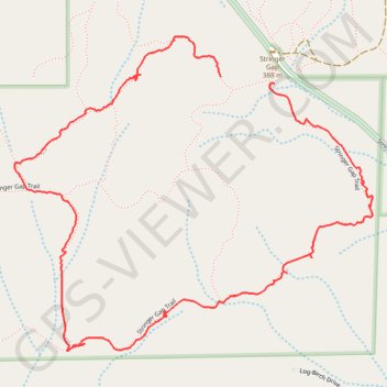
Stringer Gap Loop Trail
- Distance: 2.1 mi
- Elevation gain: 266 ft
- Maximum elevation: 1,460 ft
- Elevation loss: 230 ft
- Minimum elevation: 1,237 ft
- Moving time: 57 m 7 s
- Moving speed: 2.2 mph
- Maximum speed: 13.2 mph
- Total time: 1 h 11 m
- Global speed: 1.7 mph
Interactive trail map
Thank you for supporting this site ❤️
Make a donation
Make a donation
Gear up for your next adventure:
As an Amazon Associate, this site earns from qualifying purchases at no extra cost to you.
Trail profile
- Distance: 2.1 mi
- Elevation gain: 266 ft
- Maximum elevation: 1,460 ft
- Elevation loss: 230 ft
- Minimum elevation: 1,237 ft
- Moving time: 57 m 7 s
- Moving speed: 2.2 mph
- Maximum speed: 13.2 mph
- Total time: 1 h 11 m
- Global speed: 1.7 mph
Thank you for supporting this site ❤️
Make a donation
Make a donation
Gear up for your next adventure:
As an Amazon Associate, this site earns from qualifying purchases at no extra cost to you.
About this trail
Name: Stringer Gap Loop Trail trail, distance, elevation, map, profile, GPS track
Start: Stringer Gap Trail, Josephine County, Oregon, United States (42.37518 -123.38981)
End: Stringer Gap Trail, Josephine County, Oregon, United States (42.37533 -123.39152)
Coordinates: 42.36896 -123.39800 42.37627 -123.38672
Topography: Josephine County topographic map, elevation, terrain
Thank you for supporting this site ❤️
Make a donation
Make a donation
Gear up for your next adventure:
As an Amazon Associate, this site earns from qualifying purchases at no extra cost to you.