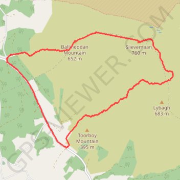
Ballineddan Mountain and Slievemaan Loop
- Distance: 7.1 mi
- Elevation gain: 1,752 ft
- Maximum elevation: 2,487 ft
- Elevation loss: 1,749 ft
- Minimum elevation: 846 ft
- Moving time: 4 h 7 m
- Moving speed: 1.7 mph
- Maximum speed: 3.4 mph
- Total time: 5 h 27 m
- Global speed: 1.3 mph
Interactive trail map
Trail profile
- Distance: 7.1 mi
- Elevation gain: 1,752 ft
- Maximum elevation: 2,487 ft
- Elevation loss: 1,749 ft
- Minimum elevation: 846 ft
- Moving time: 4 h 7 m
- Moving speed: 1.7 mph
- Maximum speed: 3.4 mph
- Total time: 5 h 27 m
- Global speed: 1.3 mph
About this trail
Name: Ballineddan Mountain and Slievemaan Loop trail, distance, elevation, map, profile, GPS track
Coordinates: 52.93645 -6.53259 52.96077 -6.47445