Make a donation
Gear up for your next adventure:
As an Amazon Associate, this site earns from qualifying purchases at no extra cost to you.
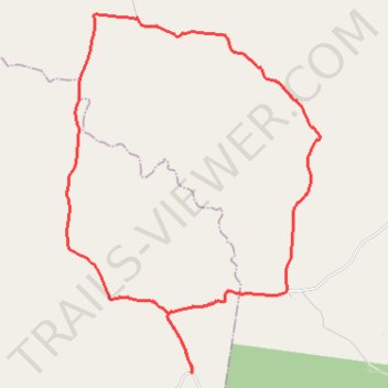
Johnstown to Elgin Vale loop
- Distance: 22.6 mi
- Elevation gain: 1,601 ft
- Maximum elevation: 1,693 ft
- Elevation loss: 1,598 ft
- Minimum elevation: 1,135 ft
- Moving time: 2 h 12 m
- Moving speed: 10.2 mph
- Maximum speed: 36.8 mph
- Total time: 2 h 33 m
- Global speed: 8.8 mph
Interactive trail map
Make a donation
Gear up for your next adventure:
As an Amazon Associate, this site earns from qualifying purchases at no extra cost to you.
Trail profile
- Distance: 22.6 mi
- Elevation gain: 1,601 ft
- Maximum elevation: 1,693 ft
- Elevation loss: 1,598 ft
- Minimum elevation: 1,135 ft
- Moving time: 2 h 12 m
- Moving speed: 10.2 mph
- Maximum speed: 36.8 mph
- Total time: 2 h 33 m
- Global speed: 8.8 mph
Make a donation
Gear up for your next adventure:
As an Amazon Associate, this site earns from qualifying purchases at no extra cost to you.
About this trail
Name: Johnstown to Elgin Vale loop trail, distance, elevation, map, profile, GPS track
End: Manumbar Road, Johnstown, South Burnett Regional, Queensland, Australia (-26.46490 152.15752)
Coordinates: -26.46518 152.11599 -26.35864 152.20006
Make a donation
Gear up for your next adventure:
As an Amazon Associate, this site earns from qualifying purchases at no extra cost to you.
Other hiking, mountain biking, running and outdoor activity trails
Click on a trail to view its statistics, map and profile.
Manumbar and Elgin Vale
Barambah, Manumbar, Elgin Vale, Queensland
Distance: 30.5 mi • Elevation gain: 2,595 ft • Maximum elevation: 1,690 ft