Make a donation
Gear up for your next adventure:
As an Amazon Associate, this site earns from qualifying purchases at no extra cost to you.
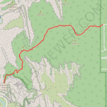
Observation Point via East Mesa Trail in Zion National Park
The East Mesa Trail to Observation Point in Zion National Park offers a breathtaking hike through diverse landscapes, taking you through scrubby desert terrain and high-altitude plateaus, culminating in a breathtaking panorama of Zion Canyon. From the vantage point at Observation Point, one can marvel at iconic formations such as Angels Landing, the Great White Throne, and the Virgin River winding through the canyon below. This trail provides a less crowded alternative to other popular hikes in the park, allowing for a tranquil and rewarding experience amidst Zion's stunning landscapes. #Hiking #Canyon #Overlook #Nature
- Distance: 7.0 mi
- Elevation gain: 784 ft
- Maximum elevation: 6,804 ft
- Elevation loss: 787 ft
- Minimum elevation: 6,398 ft
- Moving time: 2 h 37 m
- Moving speed: 2.7 mph
- Maximum speed: 4.9 mph
- Total time: 2 h 47 m
- Global speed: 2.5 mph
Interactive trail map
Make a donation
Gear up for your next adventure:
As an Amazon Associate, this site earns from qualifying purchases at no extra cost to you.
Trail profile
- Distance: 7.0 mi
- Elevation gain: 784 ft
- Maximum elevation: 6,804 ft
- Elevation loss: 787 ft
- Minimum elevation: 6,398 ft
- Moving time: 2 h 37 m
- Moving speed: 2.7 mph
- Maximum speed: 4.9 mph
- Total time: 2 h 47 m
- Global speed: 2.5 mph
Make a donation
Gear up for your next adventure:
As an Amazon Associate, this site earns from qualifying purchases at no extra cost to you.
About this trail
Name: Observation Point via East Mesa Trail in Zion National Park trail, distance, elevation, map, profile, GPS track
Coordinates: 37.27824 -112.94048 37.29698 -112.90035
Topography: Kane County topographic map, elevation, terrain
Make a donation
Gear up for your next adventure:
As an Amazon Associate, this site earns from qualifying purchases at no extra cost to you.
Other hiking, mountain biking, running and outdoor activity trails
Click on a trail to view its statistics, map and profile.