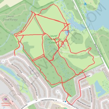
Laurel Creek Nature Centre
- Distance: 5.1 mi
- Elevation gain: 141 ft
- Maximum elevation: 1,161 ft
- Elevation loss: 141 ft
- Minimum elevation: 1,129 ft
- Moving time: 57 m 30 s
- Moving speed: 5.3 mph
- Maximum speed: 8.0 mph
- Total time: 58 m 46 s
- Global speed: 5.2 mph
Interactive trail map
Trail profile
- Distance: 5.1 mi
- Elevation gain: 141 ft
- Maximum elevation: 1,161 ft
- Elevation loss: 141 ft
- Minimum elevation: 1,129 ft
- Moving time: 57 m 30 s
- Moving speed: 5.3 mph
- Maximum speed: 8.0 mph
- Total time: 58 m 46 s
- Global speed: 5.2 mph
About this trail
Name: Laurel Creek Nature Centre trail, distance, elevation, map, profile, GPS track
Coordinates: 43.47243 -80.59229 43.48090 -80.58295