Lake Waterford
- Distance: 1.3 mi
- Elevation gain: 79 ft
- Maximum elevation: 72 ft
- Elevation loss: 43 ft
- Minimum elevation: 20 ft
- Moving time: 42 m 46 s
- Moving speed: 1.9 mph
- Maximum speed: 2.9 mph
- Total time: 45 m 3 s
- Global speed: 1.8 mph
Interactive trail map
Trail profile
- Distance: 1.3 mi
- Elevation gain: 79 ft
- Maximum elevation: 72 ft
- Elevation loss: 43 ft
- Minimum elevation: 20 ft
- Moving time: 42 m 46 s
- Moving speed: 1.9 mph
- Maximum speed: 2.9 mph
- Total time: 45 m 3 s
- Global speed: 1.8 mph
About this trail
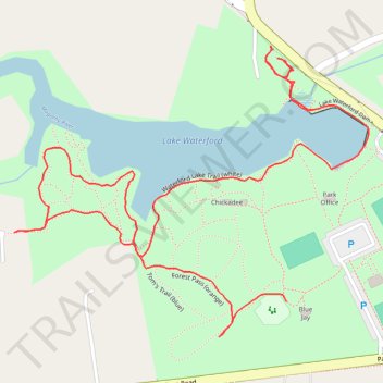
Name: Lake Waterford trail, distance, elevation, map, profile, GPS track
Coordinates: 39.11128 -76.56486 39.11534 -76.55849
Topography: Anne Arundel County topographic map, elevation, terrain
Other hiking, mountain biking, running and outdoor activity trails
Click on a trail to view its statistics, map and profile.
Lake Waterford Park
United States > Maryland > Anne Arundel County > Pasadena > Selby Grove
Distance: 2.0 mi • Elevation gain: 98 ft • Maximum elevation: 75 ft