Make a donation
Gear up for your next adventure:
As an Amazon Associate, this site earns from qualifying purchases at no extra cost to you.
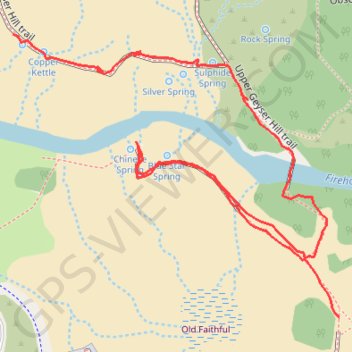
Old Faithful - Geyser Hill
Blue Star Springs - Chinese Spring - Sulphide Spring - Bronze Spring - Silver Spring - Beehive Geyser - Scissors Spring - Copper Kettle
Yellowstone National Park
- Distance: 0.7 mi
- Elevation gain: 30 ft
- Maximum elevation: 7,375 ft
- Elevation loss: 46 ft
- Minimum elevation: 7,352 ft
- Moving time: 18 m
- Moving speed: 2.2 mph
- Maximum speed: 4.4 mph
- Total time: 23 m 56 s
- Global speed: 1.7 mph
Interactive trail map
Make a donation
Gear up for your next adventure:
As an Amazon Associate, this site earns from qualifying purchases at no extra cost to you.
Trail profile
- Distance: 0.7 mi
- Elevation gain: 30 ft
- Maximum elevation: 7,375 ft
- Elevation loss: 46 ft
- Minimum elevation: 7,352 ft
- Moving time: 18 m
- Moving speed: 2.2 mph
- Maximum speed: 4.4 mph
- Total time: 23 m 56 s
- Global speed: 1.7 mph
Make a donation
Gear up for your next adventure:
As an Amazon Associate, this site earns from qualifying purchases at no extra cost to you.
About this trail
Name: Old Faithful - Geyser Hill trail, distance, elevation, map, profile, GPS track
Start: Upper Geyser Basin Trail, Teton County, Wyoming, 82180, United States (44.46055 -110.82657)
Coordinates: 44.46055 -110.83048 44.46298 -110.82657
Topography: Teton County topographic map, elevation, terrain
Make a donation
Gear up for your next adventure:
As an Amazon Associate, this site earns from qualifying purchases at no extra cost to you.