Thank you for supporting this site ❤️
Make a donation
Make a donation
Gear up for your next adventure:
As an Amazon Associate, this site earns from qualifying purchases at no extra cost to you.
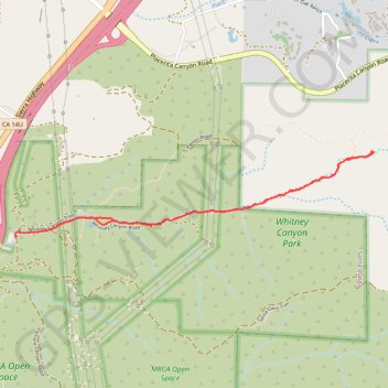
Whitney Canyon Road - Whitney Canyon Park - Angeles National Forest
- Distance: 3.2 mi
- Elevation gain: 459 ft
- Maximum elevation: 1,844 ft
- Elevation loss: 459 ft
- Minimum elevation: 1,427 ft
- Moving time: 1 h 19 m
- Moving speed: 2.5 mph
- Maximum speed: 21.9 mph
- Total time: 2 h 31 m
- Global speed: 1.3 mph
Interactive trail map
Thank you for supporting this site ❤️
Make a donation
Make a donation
Gear up for your next adventure:
As an Amazon Associate, this site earns from qualifying purchases at no extra cost to you.
Trail profile
- Distance: 3.2 mi
- Elevation gain: 459 ft
- Maximum elevation: 1,844 ft
- Elevation loss: 459 ft
- Minimum elevation: 1,427 ft
- Moving time: 1 h 19 m
- Moving speed: 2.5 mph
- Maximum speed: 21.9 mph
- Total time: 2 h 31 m
- Global speed: 1.3 mph
Thank you for supporting this site ❤️
Make a donation
Make a donation
Gear up for your next adventure:
As an Amazon Associate, this site earns from qualifying purchases at no extra cost to you.
About this trail
Name: Whitney Canyon Road - Whitney Canyon Park - Angeles National Forest trail, distance, elevation, map, profile, GPS track
Coordinates: 34.36508 -118.50052 34.37003 -118.47538
Topography: Santa Clarita topographic map, elevation, terrain
Thank you for supporting this site ❤️
Make a donation
Make a donation
Gear up for your next adventure:
As an Amazon Associate, this site earns from qualifying purchases at no extra cost to you.