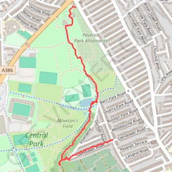
Central Park
- Distance: 1.1 mi
- Elevation gain: 46 ft
- Maximum elevation: 207 ft
- Elevation loss: 112 ft
- Minimum elevation: 98 ft
- Moving time: 31 m 9 s
- Moving speed: 2.2 mph
- Maximum speed: 7.0 mph
- Total time: 33 m 38 s
- Global speed: 2.0 mph
Interactive trail map
Trail profile
- Distance: 1.1 mi
- Elevation gain: 46 ft
- Maximum elevation: 207 ft
- Elevation loss: 112 ft
- Minimum elevation: 98 ft
- Moving time: 31 m 9 s
- Moving speed: 2.2 mph
- Maximum speed: 7.0 mph
- Total time: 33 m 38 s
- Global speed: 2.0 mph
About this trail
Name: Central Park trail, distance, elevation, map, profile, GPS track
End: 66, Trelawney Road, Peverell, Plymouth, England, PL3 4JY, United Kingdom (50.38636 -4.14263)
Coordinates: 50.38486 -4.14741 50.39397 -4.14262
Other hiking, mountain biking, running and outdoor activity trails
Click on a trail to view its statistics, map and profile.
Saltram, Chelson Meadow, Prince Rock, Tothill
United Kingdom > England > Plymouth > Plympton
Distance: 9.8 mi • Elevation gain: 620 ft • Maximum elevation: 108 ft