Thank you for supporting this site ❤️
Make a donation
Make a donation
Gear up for your next adventure:
As an Amazon Associate, this site earns from qualifying purchases at no extra cost to you.
Teaberry Trail
- Distance: 0.4 mi
- Elevation gain: 75 ft
- Maximum elevation: 1,972 ft
- Elevation loss: 75 ft
- Minimum elevation: 1,893 ft
- Moving time: 8 m 43 s
- Moving speed: 2.9 mph
- Maximum speed: 4.3 mph
- Total time: 17 m 3 s
- Global speed: 1.5 mph
Interactive trail map
Thank you for supporting this site ❤️
Make a donation
Make a donation
Gear up for your next adventure:
As an Amazon Associate, this site earns from qualifying purchases at no extra cost to you.
Trail profile
- Distance: 0.4 mi
- Elevation gain: 75 ft
- Maximum elevation: 1,972 ft
- Elevation loss: 75 ft
- Minimum elevation: 1,893 ft
- Moving time: 8 m 43 s
- Moving speed: 2.9 mph
- Maximum speed: 4.3 mph
- Total time: 17 m 3 s
- Global speed: 1.5 mph
Thank you for supporting this site ❤️
Make a donation
Make a donation
Gear up for your next adventure:
As an Amazon Associate, this site earns from qualifying purchases at no extra cost to you.
About this trail
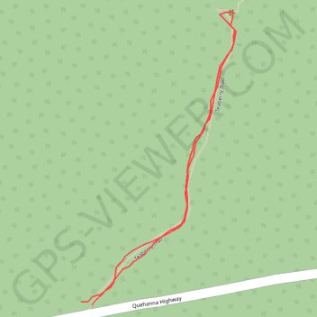
Name: Teaberry Trail trail, distance, elevation, map, profile, GPS track
Coordinates: 41.26355 -78.25188 41.26598 -78.25017
Topography: Benezette Township topographic map, elevation, terrain
Thank you for supporting this site ❤️
Make a donation
Make a donation
Gear up for your next adventure:
As an Amazon Associate, this site earns from qualifying purchases at no extra cost to you.
Other hiking, mountain biking, running and outdoor activity trails
Click on a trail to view its statistics, map and profile.
Beaver Run Loop Walk via Teaberry Trail and Quehanna East Cross Connector
United States > Pennsylvania > Elk County > Benezette Township
Distance: 5.9 mi • Elevation gain: 554 ft • Maximum elevation: 2,051 ft