Thank you for supporting this site ❤️
Make a donation
Make a donation
Gear up for your next adventure:
As an Amazon Associate, this site earns from qualifying purchases at no extra cost to you.
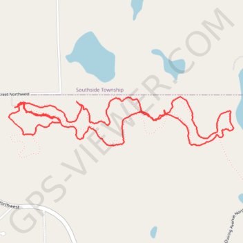
Stanley Eddy Trail
Wright County Running
- Distance: 3.6 mi
- Elevation gain: 164 ft
- Maximum elevation: 1,145 ft
- Elevation loss: 167 ft
- Minimum elevation: 1,073 ft
- Moving time: 55 m 14 s
- Moving speed: 3.9 mph
- Maximum speed: 10.6 mph
- Total time: 55 m 14 s
- Global speed: 3.9 mph
Interactive trail map
Thank you for supporting this site ❤️
Make a donation
Make a donation
Gear up for your next adventure:
As an Amazon Associate, this site earns from qualifying purchases at no extra cost to you.
Trail profile
- Distance: 3.6 mi
- Elevation gain: 164 ft
- Maximum elevation: 1,145 ft
- Elevation loss: 167 ft
- Minimum elevation: 1,073 ft
- Moving time: 55 m 14 s
- Moving speed: 3.9 mph
- Maximum speed: 10.6 mph
- Total time: 55 m 14 s
- Global speed: 3.9 mph
Thank you for supporting this site ❤️
Make a donation
Make a donation
Gear up for your next adventure:
As an Amazon Associate, this site earns from qualifying purchases at no extra cost to you.
About this trail
Name: Stanley Eddy Trail trail, distance, elevation, map, profile, GPS track
Coordinates: 45.23624 -94.24931 45.23915 -94.23031
Topography: Wright County topographic map, elevation, terrain
Thank you for supporting this site ❤️
Make a donation
Make a donation
Gear up for your next adventure:
As an Amazon Associate, this site earns from qualifying purchases at no extra cost to you.