Thank you for supporting this site ❤️
Make a donation
Make a donation
Gear up for your next adventure:
As an Amazon Associate, this site earns from qualifying purchases at no extra cost to you.
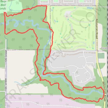
Wedgewood Loop
- Distance: 4.7 mi
- Elevation gain: 354 ft
- Maximum elevation: 2,146 ft
- Elevation loss: 351 ft
- Minimum elevation: 2,060 ft
- Moving time: 1 h 3 m
- Moving speed: 4.4 mph
- Maximum speed: 6.4 mph
- Total time: 1 h 3 m
- Global speed: 4.4 mph
Interactive trail map
Thank you for supporting this site ❤️
Make a donation
Make a donation
Gear up for your next adventure:
As an Amazon Associate, this site earns from qualifying purchases at no extra cost to you.
Trail profile
- Distance: 4.7 mi
- Elevation gain: 354 ft
- Maximum elevation: 2,146 ft
- Elevation loss: 351 ft
- Minimum elevation: 2,060 ft
- Moving time: 1 h 3 m
- Moving speed: 4.4 mph
- Maximum speed: 6.4 mph
- Total time: 1 h 3 m
- Global speed: 4.4 mph
Thank you for supporting this site ❤️
Make a donation
Make a donation
Gear up for your next adventure:
As an Amazon Associate, this site earns from qualifying purchases at no extra cost to you.
About this trail
Name: Wedgewood Loop trail, distance, elevation, map, profile, GPS track
Start: Outter Waxwing, Grande Prairie, Alberta, T8W 0H1, Canada (55.13328 -118.79509)
End: Outter Waxwing, Grande Prairie, Alberta, T8W 0H1, Canada (55.13333 -118.79538)
Coordinates: 55.11854 -118.79538 55.13438 -118.76671
Thank you for supporting this site ❤️
Make a donation
Make a donation
Gear up for your next adventure:
As an Amazon Associate, this site earns from qualifying purchases at no extra cost to you.