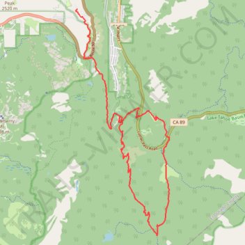
Tahoe Rim Trail and Christmas Valley Trail MTB Loop
- Distance: 12.6 mi
- Elevation gain: 2,031 ft
- Maximum elevation: 8,100 ft
- Elevation loss: 2,969 ft
- Minimum elevation: 6,516 ft
- Moving time: 2 h 22 m
- Moving speed: 5.3 mph
- Maximum speed: 29.0 mph
- Total time: 2 h 54 m
- Global speed: 4.3 mph
Interactive trail map
Trail profile
- Distance: 12.6 mi
- Elevation gain: 2,031 ft
- Maximum elevation: 8,100 ft
- Elevation loss: 2,969 ft
- Minimum elevation: 6,516 ft
- Moving time: 2 h 22 m
- Moving speed: 5.3 mph
- Maximum speed: 29.0 mph
- Total time: 2 h 54 m
- Global speed: 4.3 mph
About this trail
Name: Tahoe Rim Trail and Christmas Valley Trail MTB Loop trail, distance, elevation, map, profile, GPS track
End: South Upper Truckee Road, El Dorado County, California, 95721, United States (38.79587 -120.01780)
Coordinates: 38.76012 -120.03450 38.82751 -119.99873
Topography: El Dorado County topographic map, elevation, terrain