Import a GPX file

Falcons Lookout via Ironbark Gorge Track in Werribee Gorge State Park

  • Distance: 2.5 mi
  • Elevation gain: 699 ft
  • Maximum elevation: 1,302 ft
  • Elevation loss: 696 ft
  • Minimum elevation: 1,001 ft

Interactive trail map

Trail profile

  • Distance: 2.5 mi
  • Elevation gain: 699 ft
  • Maximum elevation: 1,302 ft
  • Elevation loss: 696 ft
  • Minimum elevation: 1,001 ft

About this trail
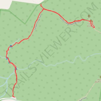
Name: Falcons Lookout via Ironbark Gorge Track in Werribee Gorge State Park trail, distance, elevation, map, profile, GPS track

Start: Ironbark Gorge Trailhead, Ironbark Gorge Track, Ingliston, Victoria, 3342, Australia (-37.66558 144.33451)

End: Ironbark Gorge Trailhead, Ironbark Gorge Track, Ingliston, Victoria, 3342, Australia (-37.66558 144.33437)

Coordinates: -37.66559 144.33351 -37.65708 144.34368

Gear up for your next adventure:

🧺Microfiber Travel Towels - Compact and fast-drying towels for trail use
📚Navigation Handbooks - Master the art of reading topographic maps and using a compass
🕶️Glacier Sunglasses - Side shields to protect eyes from high-altitude snow glare
🎒Hydration Pack - Hands‑free water reservoir for long hikes
👖Convertible Hiking Pants - Versatile zip-off pants for changing altitudes and temperatures

As an Amazon Associate, this site earns from qualifying purchases at no extra cost to you.