Make a donation
Gear up for your next adventure:
As an Amazon Associate, this site earns from qualifying purchases at no extra cost to you.
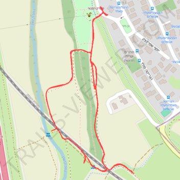
Loop walk near Kishon Park
- Distance: 1.7 mi
- Elevation gain: 33 ft
- Maximum elevation: 89 ft
- Elevation loss: 33 ft
- Minimum elevation: 66 ft
- Moving time: 38 m 39 s
- Moving speed: 2.6 mph
- Maximum speed: 3.6 mph
- Total time: 46 m 35 s
- Global speed: 2.2 mph
Interactive trail map
Make a donation
Gear up for your next adventure:
As an Amazon Associate, this site earns from qualifying purchases at no extra cost to you.
Trail profile
- Distance: 1.7 mi
- Elevation gain: 33 ft
- Maximum elevation: 89 ft
- Elevation loss: 33 ft
- Minimum elevation: 66 ft
- Moving time: 38 m 39 s
- Moving speed: 2.6 mph
- Maximum speed: 3.6 mph
- Total time: 46 m 35 s
- Global speed: 2.2 mph
Make a donation
Gear up for your next adventure:
As an Amazon Associate, this site earns from qualifying purchases at no extra cost to you.
About this trail
Name: Loop walk near Kishon Park trail, distance, elevation, map, profile, GPS track
Start: 7224, Kiryat Tivon, Haifa Subdistrict, Haifa District, 3608002, Israel (32.68744 35.10931)
End: 7224, Kiryat Tivon, Haifa Subdistrict, Haifa District, 3608002, Israel (32.68741 35.10936)
Coordinates: 32.68741 35.10646 32.69203 35.10936
Make a donation
Gear up for your next adventure:
As an Amazon Associate, this site earns from qualifying purchases at no extra cost to you.
Other hiking, mountain biking, running and outdoor activity trails
Click on a trail to view its statistics, map and profile.
Home78Rec
Israel > Haifa District > Nesher
Distance: 48.7 mi • Elevation gain: 4,852 ft • Maximum elevation: 1,512 ft