Thank you for supporting this site ❤️
Make a donation
Make a donation
Gear up for your next adventure:
As an Amazon Associate, this site earns from qualifying purchases at no extra cost to you.
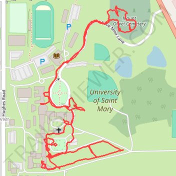
University of Saint Mary
- Distance: 2.4 mi
- Elevation gain: 131 ft
- Maximum elevation: 938 ft
- Elevation loss: 118 ft
- Minimum elevation: 883 ft
- Moving time: 1 h 2 m
- Moving speed: 2.3 mph
- Maximum speed: 3.9 mph
- Total time: 1 h 29 m
- Global speed: 1.6 mph
Interactive trail map
Thank you for supporting this site ❤️
Make a donation
Make a donation
Gear up for your next adventure:
As an Amazon Associate, this site earns from qualifying purchases at no extra cost to you.
Trail profile
- Distance: 2.4 mi
- Elevation gain: 131 ft
- Maximum elevation: 938 ft
- Elevation loss: 118 ft
- Minimum elevation: 883 ft
- Moving time: 1 h 2 m
- Moving speed: 2.3 mph
- Maximum speed: 3.9 mph
- Total time: 1 h 29 m
- Global speed: 1.6 mph
Thank you for supporting this site ❤️
Make a donation
Make a donation
Gear up for your next adventure:
As an Amazon Associate, this site earns from qualifying purchases at no extra cost to you.
About this trail
Name: University of Saint Mary trail, distance, elevation, map, profile, GPS track
Coordinates: 39.27543 -94.90743 39.28118 -94.90307
Topography: Leavenworth topographic map, elevation, terrain
Thank you for supporting this site ❤️
Make a donation
Make a donation
Gear up for your next adventure:
As an Amazon Associate, this site earns from qualifying purchases at no extra cost to you.