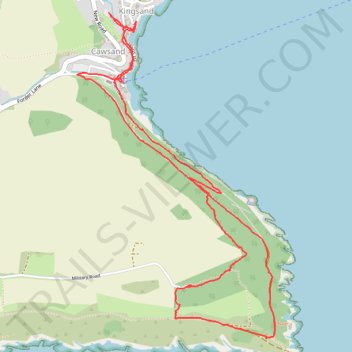
Loop Walk from Cawsand, Cornwall
- Distance: 3.9 mi
- Elevation gain: 617 ft
- Maximum elevation: 351 ft
- Elevation loss: 620 ft
- Minimum elevation: 13 ft
- Moving time: 1 h 49 m
- Moving speed: 2.1 mph
- Maximum speed: 4.3 mph
- Total time: 3 h 2 m
- Global speed: 1.3 mph
Interactive trail map
Trail profile
- Distance: 3.9 mi
- Elevation gain: 617 ft
- Maximum elevation: 351 ft
- Elevation loss: 620 ft
- Minimum elevation: 13 ft
- Moving time: 1 h 49 m
- Moving speed: 2.1 mph
- Maximum speed: 4.3 mph
- Total time: 3 h 2 m
- Global speed: 1.3 mph
About this trail
Name: Loop Walk from Cawsand, Cornwall trail, distance, elevation, map, profile, GPS track
Coordinates: 50.31860 -4.20505 50.33411 -4.19027
Other hiking, mountain biking, running and outdoor activity trails
Click on a trail to view its statistics, map and profile.
Cawsand, Anthony, Torpoint
United Kingdom > England > Cornwall > Cawsand
Distance: 10.1 mi • Elevation gain: 1,302 ft • Maximum elevation: 371 ft
Mount Edgcumbe
United Kingdom > England > Plymouth
Distance: 8.9 mi • Elevation gain: 1,142 ft • Maximum elevation: 299 ft