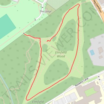
Loop walk in Elmfield Wood
- Distance: 0.6 mi
- Elevation gain: 26 ft
- Maximum elevation: 217 ft
- Elevation loss: 33 ft
- Minimum elevation: 184 ft
- Moving time: 14 m 57 s
- Moving speed: 2.2 mph
- Maximum speed: 9.0 mph
- Total time: 17 m 19 s
- Global speed: 1.9 mph
Interactive trail map
Trail profile
- Distance: 0.6 mi
- Elevation gain: 26 ft
- Maximum elevation: 217 ft
- Elevation loss: 33 ft
- Minimum elevation: 184 ft
- Moving time: 14 m 57 s
- Moving speed: 2.2 mph
- Maximum speed: 9.0 mph
- Total time: 17 m 19 s
- Global speed: 1.9 mph
About this trail
Name: Loop walk in Elmfield Wood trail, distance, elevation, map, profile, GPS track
Coordinates: 51.38660 0.03146 51.38960 0.03421
Other hiking, mountain biking, running and outdoor activity trails
Click on a trail to view its statistics, map and profile.
Scroginhall Wood Loop
United Kingdom > England > London
Distance: 2.1 mi • Elevation gain: 62 ft • Maximum elevation: 210 ft
Norman Park, Scrogginhall Wood and Elmfield Wood
United Kingdom > England > London
Distance: 2.1 mi • Elevation gain: 79 ft • Maximum elevation: 213 ft
Norman Park and Scrogginhall Wood loop
United Kingdom > England > London
Distance: 2.9 mi • Elevation gain: 92 ft • Maximum elevation: 200 ft
Scrogginhall Wood and Farm
United Kingdom > England > London
Distance: 2.5 mi • Elevation gain: 98 ft • Maximum elevation: 223 ft
Elmfield Wood
United Kingdom > England > London
Distance: 1.6 mi • Elevation gain: 82 ft • Maximum elevation: 217 ft