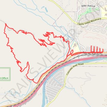
Burning Mountain loop via Ward Peak and Fire in the Mountain trails
- Distance: 10.5 mi
- Elevation gain: 2,425 ft
- Maximum elevation: 7,149 ft
- Elevation loss: 2,425 ft
- Minimum elevation: 5,554 ft
- Moving time: 1 h 54 m
- Moving speed: 5.5 mph
- Maximum speed: 27.0 mph
- Total time: 2 h 20 s
- Global speed: 5.2 mph
Interactive trail map
Trail profile
- Distance: 10.5 mi
- Elevation gain: 2,425 ft
- Maximum elevation: 7,149 ft
- Elevation loss: 2,425 ft
- Minimum elevation: 5,554 ft
- Moving time: 1 h 54 m
- Moving speed: 5.5 mph
- Maximum speed: 27.0 mph
- Total time: 2 h 20 s
- Global speed: 5.2 mph
About this trail
Name: Burning Mountain loop via Ward Peak and Fire in the Mountain trails trail, distance, elevation, map, profile, GPS track
Coordinates: 39.56334 -107.56534 39.57909 -107.53135
Topography: Garfield County topographic map, elevation, terrain