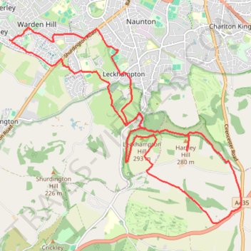
Cheltenham Seven Springs Loop Walking
- Distance: 11.8 mi
- Elevation gain: 1,319 ft
- Maximum elevation: 958 ft
- Elevation loss: 1,322 ft
- Minimum elevation: 180 ft
Interactive trail map
Trail profile
- Distance: 11.8 mi
- Elevation gain: 1,319 ft
- Maximum elevation: 958 ft
- Elevation loss: 1,322 ft
- Minimum elevation: 180 ft
About this trail
Name: Cheltenham Seven Springs Loop Walking trail, distance, elevation, map, profile, GPS track
Coordinates: 51.84909 -2.11387 51.88364 -2.04753
Other hiking, mountain biking, running and outdoor activity trails
Click on a trail to view its statistics, map and profile.
Dean2023-311
United Kingdom > England > Oxfordshire > Oxford
Distance: 192.8 mi • Elevation gain: 11,043 ft • Maximum elevation: 951 ft