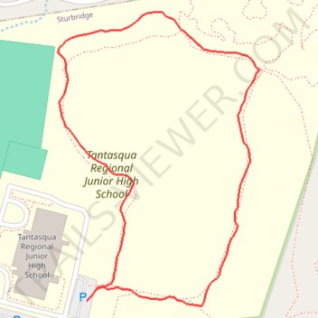
The "Warriors Way" trail at Tantasqua Trails
Tantasqua, Sturbridge, Massachusetts
- Distance: 0.7 mi
- Elevation gain: 56 ft
- Maximum elevation: 758 ft
- Elevation loss: 59 ft
- Minimum elevation: 712 ft
- Moving time: 17 m 55 s
- Moving speed: 2.3 mph
- Maximum speed: 6.7 mph
- Total time: 18 m 33 s
- Global speed: 2.3 mph
Interactive trail map
Trail profile
- Distance: 0.7 mi
- Elevation gain: 56 ft
- Maximum elevation: 758 ft
- Elevation loss: 59 ft
- Minimum elevation: 712 ft
- Moving time: 17 m 55 s
- Moving speed: 2.3 mph
- Maximum speed: 6.7 mph
- Total time: 18 m 33 s
- Global speed: 2.3 mph
About this trail
Name: The "Warriors Way" trail at Tantasqua Trails trail, distance, elevation, map, profile, GPS track
End: Pond Loop, Sturbridge, Worcester County, Massachusetts, 01518, United States (42.15957 -72.12617)
Coordinates: 42.15952 -72.12660 42.16274 -72.12362
Topography: Worcester County topographic map, elevation, terrain