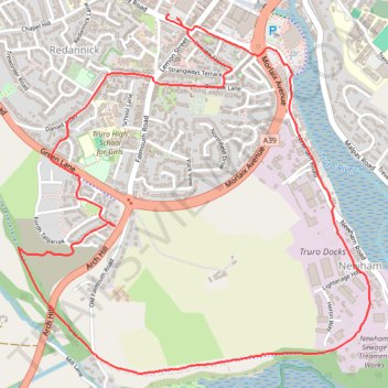
Newham loop Truro
- Distance: 3.6 mi
- Elevation gain: 308 ft
- Maximum elevation: 233 ft
- Elevation loss: 308 ft
- Minimum elevation: 0 ft
- Moving time: 38 m 23 s
- Moving speed: 5.7 mph
- Maximum speed: 9.1 mph
- Total time: 38 m 23 s
- Global speed: 5.7 mph
Interactive trail map
Trail profile
- Distance: 3.6 mi
- Elevation gain: 308 ft
- Maximum elevation: 233 ft
- Elevation loss: 308 ft
- Minimum elevation: 0 ft
- Moving time: 38 m 23 s
- Moving speed: 5.7 mph
- Maximum speed: 9.1 mph
- Total time: 38 m 23 s
- Global speed: 5.7 mph
About this trail
Name: Newham loop Truro trail, distance, elevation, map, profile, GPS track
Start: Charles Street, Ferris Town, Truro, Cornwall, England, TR1 2PQ, United Kingdom (50.26179 -5.05413)
End: Charles Street, Ferris Town, Truro, Cornwall, England, TR1 2PQ, United Kingdom (50.26166 -5.05369)
Coordinates: 50.24849 -5.06287 50.26179 -5.04250