Thank you for supporting this site ❤️
Make a donation
Make a donation
Gear up for your next adventure:
As an Amazon Associate, this site earns from qualifying purchases at no extra cost to you.
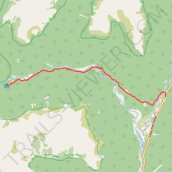
Nina Valley Track
- Distance: 5.2 mi
- Elevation gain: 413 ft
- Maximum elevation: 2,470 ft
- Elevation loss: 768 ft
- Minimum elevation: 2,100 ft
- Moving time: 2 h 50 m
- Moving speed: 1.8 mph
- Maximum speed: 4.8 mph
- Total time: 4 h 20 m
- Global speed: 1.2 mph
Interactive trail map
Thank you for supporting this site ❤️
Make a donation
Make a donation
Gear up for your next adventure:
As an Amazon Associate, this site earns from qualifying purchases at no extra cost to you.
Trail profile
- Distance: 5.2 mi
- Elevation gain: 413 ft
- Maximum elevation: 2,470 ft
- Elevation loss: 768 ft
- Minimum elevation: 2,100 ft
- Moving time: 2 h 50 m
- Moving speed: 1.8 mph
- Maximum speed: 4.8 mph
- Total time: 4 h 20 m
- Global speed: 1.2 mph
Thank you for supporting this site ❤️
Make a donation
Make a donation
Gear up for your next adventure:
As an Amazon Associate, this site earns from qualifying purchases at no extra cost to you.
About this trail
Name: Nina Valley Track trail, distance, elevation, map, profile, GPS track
Start: Nina Valley Track, Hurunui District, Canterbury, New Zealand (-42.46590 172.32214)
End: Lewis Pass Road, Hurunui District, Canterbury, New Zealand (-42.47007 172.39776)
Coordinates: -42.47282 172.32214 -42.45941 172.39792
Thank you for supporting this site ❤️
Make a donation
Make a donation
Gear up for your next adventure:
As an Amazon Associate, this site earns from qualifying purchases at no extra cost to you.
Other hiking, mountain biking, running and outdoor activity trails
Click on a trail to view its statistics, map and profile.