Make a donation
Gear up for your next adventure:
As an Amazon Associate, this site earns from qualifying purchases at no extra cost to you.
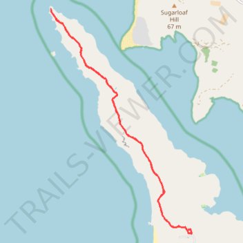
Tomales Point Trail in Point Reyes National Seashore
The Tomales Point Trail in Point Reyes National Seashore offers hikers stunning views of the Pacific Ocean and Tomales Bay, with the opportunity to observe tule elk grazing in their natural habitat. Traversing coastal bluffs and open ridges, the trail showcases the rugged beauty of the California coastline. Along the way, remnants of the historic Pierce Point Ranch provide a glimpse into the area's ranching past. #Hiking #Sea #Pacific #Ocean #Coast #Nature
- Distance: 9.6 mi
- Elevation gain: 1,299 ft
- Maximum elevation: 531 ft
- Elevation loss: 1,302 ft
- Minimum elevation: 3 ft
- Moving time: 2 h 11 m
- Moving speed: 4.3 mph
- Maximum speed: 9.1 mph
- Total time: 2 h 15 m
- Global speed: 4.2 mph
Interactive trail map
Make a donation
Gear up for your next adventure:
As an Amazon Associate, this site earns from qualifying purchases at no extra cost to you.
Trail profile
- Distance: 9.6 mi
- Elevation gain: 1,299 ft
- Maximum elevation: 531 ft
- Elevation loss: 1,302 ft
- Minimum elevation: 3 ft
- Moving time: 2 h 11 m
- Moving speed: 4.3 mph
- Maximum speed: 9.1 mph
- Total time: 2 h 15 m
- Global speed: 4.2 mph
Make a donation
Gear up for your next adventure:
As an Amazon Associate, this site earns from qualifying purchases at no extra cost to you.
About this trail
Name: Tomales Point Trail in Point Reyes National Seashore trail, distance, elevation, map, profile, GPS track
Coordinates: 38.18913 -122.99485 38.24023 -122.95403
Topography: Marin County topographic map, elevation, terrain
Make a donation
Gear up for your next adventure:
As an Amazon Associate, this site earns from qualifying purchases at no extra cost to you.
Other hiking, mountain biking, running and outdoor activity trails
Click on a trail to view its statistics, map and profile.
Tomales Point Trail in Point Reyes National Seashore
United States > California > Marin County
The Tomales Point Trail in Point Reyes National Seashore offers dramatic coastal views, with sweeping panoramas of both the Pacific Ocean and Tomales Bay. As you hike along the exposed bluffs, you'll encounter a variety of natural wonders, including the iconic Tule Elk, often spotted lounging in the grasslands…
Distance: 9.6 mi • Elevation gain: 1,339 ft • Maximum elevation: 531 ft