Thank you for supporting this site ❤️
Make a donation
Make a donation
Gear up for your next adventure:
As an Amazon Associate, this site earns from qualifying purchases at no extra cost to you.
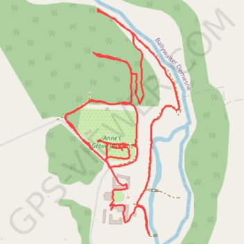
Annes Grove House Gardens
- Distance: 1.8 mi
- Elevation gain: 141 ft
- Maximum elevation: 226 ft
- Elevation loss: 141 ft
- Minimum elevation: 157 ft
- Moving time: 48 m 12 s
- Moving speed: 2.2 mph
- Maximum speed: 3.4 mph
- Total time: 55 m 37 s
- Global speed: 1.9 mph
Interactive trail map
Thank you for supporting this site ❤️
Make a donation
Make a donation
Gear up for your next adventure:
As an Amazon Associate, this site earns from qualifying purchases at no extra cost to you.
Trail profile
- Distance: 1.8 mi
- Elevation gain: 141 ft
- Maximum elevation: 226 ft
- Elevation loss: 141 ft
- Minimum elevation: 157 ft
- Moving time: 48 m 12 s
- Moving speed: 2.2 mph
- Maximum speed: 3.4 mph
- Total time: 55 m 37 s
- Global speed: 1.9 mph
Thank you for supporting this site ❤️
Make a donation
Make a donation
Gear up for your next adventure:
As an Amazon Associate, this site earns from qualifying purchases at no extra cost to you.
About this trail
Name: Annes Grove House Gardens trail, distance, elevation, map, profile, GPS track
Coordinates: 52.19406 -8.46755 52.19874 -8.46369
Thank you for supporting this site ❤️
Make a donation
Make a donation
Gear up for your next adventure:
As an Amazon Associate, this site earns from qualifying purchases at no extra cost to you.
Other hiking, mountain biking, running and outdoor activity trails
Click on a trail to view its statistics, map and profile.
Thurles - Cork
Ireland > County Tipperary > Thurles
#Bike
Distance: 80.6 mi • Elevation gain: 3,730 ft • Maximum elevation: 778 ft