Thank you for supporting this site ❤️
Make a donation
Make a donation
Gear up for your next adventure:
As an Amazon Associate, this site earns from qualifying purchases at no extra cost to you.
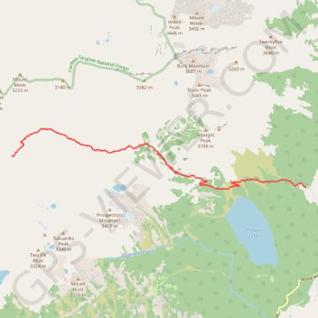
Backpacking Death Canyon
Backpacking, hiking
- Distance: 8.9 mi
- Elevation gain: 2,730 ft
- Maximum elevation: 8,556 ft
- Elevation loss: 938 ft
- Minimum elevation: 6,716 ft
- Moving time: 3 h 34 m
- Moving speed: 2.5 mph
- Maximum speed: 7.3 mph
- Total time: 5 h 25 m
- Global speed: 1.6 mph
Interactive trail map
Thank you for supporting this site ❤️
Make a donation
Make a donation
Gear up for your next adventure:
As an Amazon Associate, this site earns from qualifying purchases at no extra cost to you.
Trail profile
- Distance: 8.9 mi
- Elevation gain: 2,730 ft
- Maximum elevation: 8,556 ft
- Elevation loss: 938 ft
- Minimum elevation: 6,716 ft
- Moving time: 3 h 34 m
- Moving speed: 2.5 mph
- Maximum speed: 7.3 mph
- Total time: 5 h 25 m
- Global speed: 1.6 mph
Thank you for supporting this site ❤️
Make a donation
Make a donation
Gear up for your next adventure:
As an Amazon Associate, this site earns from qualifying purchases at no extra cost to you.
About this trail
Name: Backpacking Death Canyon trail, distance, elevation, map, profile, GPS track
Start: Teton County, Wyoming, United States (43.65511 -110.77673)
End: Death Canyon Trail, Teton County, Wyoming, United States (43.66379 -110.88524)
Coordinates: 43.65478 -110.88530 43.67101 -110.77668
Topography: Teton County topographic map, elevation, terrain
Thank you for supporting this site ❤️
Make a donation
Make a donation
Gear up for your next adventure:
As an Amazon Associate, this site earns from qualifying purchases at no extra cost to you.