Thank you for supporting this site ❤️
Make a donation
Make a donation
Gear up for your next adventure:
As an Amazon Associate, this site earns from qualifying purchases at no extra cost to you.
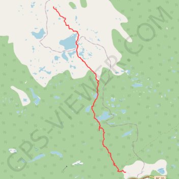
Rainbow Range Trail
- Distance: 5.8 mi
- Elevation gain: 161 ft
- Maximum elevation: 6,122 ft
- Elevation loss: 1,368 ft
- Minimum elevation: 4,911 ft
- Moving time: 2 h 18 m
- Moving speed: 2.5 mph
- Maximum speed: 39.9 mph
- Total time: 3 h 48 m
- Global speed: 1.5 mph
Interactive trail map
Thank you for supporting this site ❤️
Make a donation
Make a donation
Gear up for your next adventure:
As an Amazon Associate, this site earns from qualifying purchases at no extra cost to you.
Trail profile
- Distance: 5.8 mi
- Elevation gain: 161 ft
- Maximum elevation: 6,122 ft
- Elevation loss: 1,368 ft
- Minimum elevation: 4,911 ft
- Moving time: 2 h 18 m
- Moving speed: 2.5 mph
- Maximum speed: 39.9 mph
- Total time: 3 h 48 m
- Global speed: 1.5 mph
Thank you for supporting this site ❤️
Make a donation
Make a donation
Gear up for your next adventure:
As an Amazon Associate, this site earns from qualifying purchases at no extra cost to you.
About this trail
Name: Rainbow Range Trail trail, distance, elevation, map, profile, GPS track
Coordinates: 52.53492 -125.85564 52.59199 -125.81468
Thank you for supporting this site ❤️
Make a donation
Make a donation
Gear up for your next adventure:
As an Amazon Associate, this site earns from qualifying purchases at no extra cost to you.