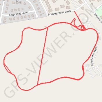
Taylor Farm Loop trail and approach paths
- Distance: 3.3 mi
- Elevation gain: 30 ft
- Maximum elevation: 167 ft
- Elevation loss: 30 ft
- Minimum elevation: 154 ft
- Moving time: 24 m 49 s
- Moving speed: 8.0 mph
- Maximum speed: 14.3 mph
- Total time: 24 m 49 s
- Global speed: 8.0 mph
Interactive trail map
Trail profile
- Distance: 3.3 mi
- Elevation gain: 30 ft
- Maximum elevation: 167 ft
- Elevation loss: 30 ft
- Minimum elevation: 154 ft
- Moving time: 24 m 49 s
- Moving speed: 8.0 mph
- Maximum speed: 14.3 mph
- Total time: 24 m 49 s
- Global speed: 8.0 mph
About this trail
Name: Taylor Farm Loop trail and approach paths trail, distance, elevation, map, profile, GPS track
Coordinates: 37.51113 -77.29821 37.51580 -77.29119
Topography: Henrico County topographic map, elevation, terrain
Other hiking, mountain biking, running and outdoor activity trails
Click on a trail to view its statistics, map and profile.
Cap2Cap 2021
United States > Virginia > James City County
Great day
Distance: 52.5 mi • Elevation gain: 1,283 ft • Maximum elevation: 167 ft