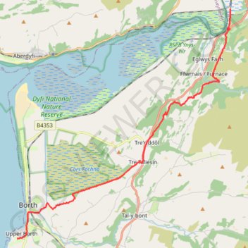
Welsh coastal path
- Distance: 10.8 mi
- Elevation gain: 925 ft
- Maximum elevation: 394 ft
- Elevation loss: 1,030 ft
- Minimum elevation: 0 ft
- Moving time: 4 h 1 m
- Moving speed: 2.7 mph
- Maximum speed: 7.0 mph
- Total time: 4 h 18 m
- Global speed: 2.5 mph
Interactive trail map
Trail profile
- Distance: 10.8 mi
- Elevation gain: 925 ft
- Maximum elevation: 394 ft
- Elevation loss: 1,030 ft
- Minimum elevation: 0 ft
- Moving time: 4 h 1 m
- Moving speed: 2.7 mph
- Maximum speed: 7.0 mph
- Total time: 4 h 18 m
- Global speed: 2.5 mph
About this trail
Name: Welsh coastal path trail, distance, elevation, map, profile, GPS track
Coordinates: 52.47520 -4.05740 52.56279 -3.92388