Make a donation
Gear up for your next adventure:
As an Amazon Associate, this site earns from qualifying purchases at no extra cost to you.
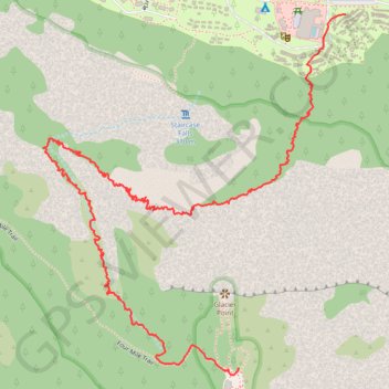
Ledge Trail to Glacier Point
Mariposa County Hiking
- Distance: 2.6 mi
- Elevation gain: 4,734 ft
- Maximum elevation: 7,208 ft
- Elevation loss: 1,575 ft
- Minimum elevation: 4,035 ft
- Moving time: 1 h 44 m
- Moving speed: 1.5 mph
- Maximum speed: 8.8 mph
- Total time: 5 h 28 m
- Global speed: 0.5 mph
Interactive trail map
Make a donation
Gear up for your next adventure:
As an Amazon Associate, this site earns from qualifying purchases at no extra cost to you.
Trail profile
- Distance: 2.6 mi
- Elevation gain: 4,734 ft
- Maximum elevation: 7,208 ft
- Elevation loss: 1,575 ft
- Minimum elevation: 4,035 ft
- Moving time: 1 h 44 m
- Moving speed: 1.5 mph
- Maximum speed: 8.8 mph
- Total time: 5 h 28 m
- Global speed: 0.5 mph
Make a donation
Gear up for your next adventure:
As an Amazon Associate, this site earns from qualifying purchases at no extra cost to you.
About this trail
Name: Ledge Trail to Glacier Point trail, distance, elevation, map, profile, GPS track
Coordinates: 37.72870 -119.57926 37.73748 -119.56993
Topography: Mariposa County topographic map, elevation, terrain
Make a donation
Gear up for your next adventure:
As an Amazon Associate, this site earns from qualifying purchases at no extra cost to you.
Other hiking, mountain biking, running and outdoor activity trails
Click on a trail to view its statistics, map and profile.
Glacier Point
United States > California > Mariposa County > Curry Village
Starting at Four Mile Trailhead in Yosemite Valley, the route joins the Four Mile Trail and begins its steady climb from the valley floor above the Merced River corridor. It first rises through forested slopes near Sentinel Creek, with early views opening toward Sentinel Rock and the meadows of Yosemite…
Distance: 4.8 mi • Elevation gain: 4,101 ft • Maximum elevation: 7,208 ft
Sentinel Dome, Glacier Point, Union Point and Taft Point Loop (Yosemite)
United States > California > Mariposa County
From Sentinel Dome Trailhead, the loop begins among conifer forest, meadow and open granite before climbing toward Sentinel Dome, where the landscape opens to broad views over Yosemite Valley, Half Dome and the high Sierra. The route then swings toward Glacier Point, one of Yosemite’s classic overlooks above…
Distance: 13.3 mi • Elevation gain: 5,827 ft • Maximum elevation: 8,130 ft
Nevada falls hike
United States > California > Mariposa County > Curry Village
Distance: 10.0 mi • Elevation gain: 4,636 ft • Maximum elevation: 6,007 ft
Glacier Point and Union Point via Four Mile Trail
United States > California > Mariposa County > Yosemite Village > Yosemite Lodge
From Yosemite Valley, the Four Mile Trail climbs away from the Merced River through forested slopes and long switchbacks on the south wall of the valley, steadily opening views toward Sentinel Rock, El Capitan, Yosemite Falls, and the granite cliffs that frame the valley floor. Higher on the route, the path…
Distance: 9.4 mi • Elevation gain: 5,404 ft • Maximum elevation: 7,208 ft
Make a donation
Gear up for your next adventure:
As an Amazon Associate, this site earns from qualifying purchases at no extra cost to you.
Four Mile Trail in Yosemite National Park
United States > California > Mariposa County > Yosemite Village > Yosemite Lodge
The Four Mile Trail in Yosemite National Park provides hikers with a challenging yet rewarding experience. As you ascend the trail, you'll be treated to ever-changing views of Yosemite Valley, including dramatic overlooks of Yosemite Falls, El Capitan, and Bridalveil Fall, with distant glimpses of the Sierra…
Distance: 10.3 mi • Elevation gain: 5,262 ft • Maximum elevation: 7,208 ft
Four Mile Trail to Glacier Point and Union Point in Yosemite National Park
United States > California > Mariposa County > Yosemite Village > Yosemite Lodge
The Four Mile Trail in Yosemite National Park offers hikers a strenuous ascent from Yosemite Valley to Glacier Point, providing panoramic views of iconic landmarks. Along the route, hikers can observe the grandeur of El Capitan and Yosemite Falls, the expansive vistas of Yosemite Valley, and the impressive…
Distance: 10.0 mi • Elevation gain: 5,489 ft • Maximum elevation: 7,208 ft
Glacier Point via Four Mile Trail in Yosemite National Park
United States > California > Mariposa County > Yosemite Village > Yosemite Lodge
Hiking the Four-Mile Trail to Glacier Point offers some of the best views in Yosemite National Park, with expansive vistas unfolding gradually as you ascend. Along the way, hikers can admire iconic landmarks like Yosemite Falls, El Capitan, and Half Dome, as well as the deep reaches of Tenaya Canyon. Though…
Distance: 4.7 mi • Elevation gain: 4,114 ft • Maximum elevation: 7,244 ft
Make a donation
Gear up for your next adventure:
As an Amazon Associate, this site earns from qualifying purchases at no extra cost to you.