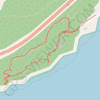
Woodland loop walk Balmacara
- Distance: 0.8 mi
- Elevation gain: 157 ft
- Maximum elevation: 138 ft
- Elevation loss: 180 ft
- Minimum elevation: 26 ft
- Moving time: 24 m 29 s
- Moving speed: 1.9 mph
- Maximum speed: 5.1 mph
- Total time: 28 m 18 s
- Global speed: 1.7 mph
Interactive trail map
Trail profile
- Distance: 0.8 mi
- Elevation gain: 157 ft
- Maximum elevation: 138 ft
- Elevation loss: 180 ft
- Minimum elevation: 26 ft
- Moving time: 24 m 29 s
- Moving speed: 1.9 mph
- Maximum speed: 5.1 mph
- Total time: 28 m 18 s
- Global speed: 1.7 mph
About this trail
Name: Woodland loop walk Balmacara trail, distance, elevation, map, profile, GPS track
Start: Glaick, Balmacara, Highland, Scotland, IV40 8DN, United Kingdom (57.28378 -5.65821)
End: Glaick, Balmacara, Highland, Scotland, IV40 8DN, United Kingdom (57.28435 -5.65692)
Coordinates: 57.28166 -5.66349 57.28435 -5.65692