Make a donation
Gear up for your next adventure:
As an Amazon Associate, this site earns from qualifying purchases at no extra cost to you.
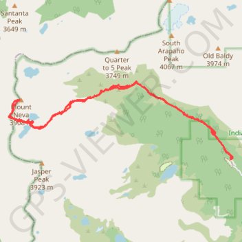
Route to Mount Neva in Roosevelt National Forest via Arapaho Pass Trail and Neva Lakes
- Distance: 9.2 mi
- Elevation gain: 3,166 ft
- Maximum elevation: 12,812 ft
- Elevation loss: 3,166 ft
- Minimum elevation: 10,138 ft
- Moving time: 4 h 40 m
- Moving speed: 2.0 mph
- Maximum speed: 3.5 mph
- Total time: 5 h 37 m
- Global speed: 1.6 mph
Interactive trail map
Make a donation
Gear up for your next adventure:
As an Amazon Associate, this site earns from qualifying purchases at no extra cost to you.
Trail profile
- Distance: 9.2 mi
- Elevation gain: 3,166 ft
- Maximum elevation: 12,812 ft
- Elevation loss: 3,166 ft
- Minimum elevation: 10,138 ft
- Moving time: 4 h 40 m
- Moving speed: 2.0 mph
- Maximum speed: 3.5 mph
- Total time: 5 h 37 m
- Global speed: 1.6 mph
Make a donation
Gear up for your next adventure:
As an Amazon Associate, this site earns from qualifying purchases at no extra cost to you.
About this trail
Name: Route to Mount Neva in Roosevelt National Forest via Arapaho Pass Trail and Neva Lakes trail, distance, elevation, map, profile, GPS track
Start: Arapaho Pass Trail, Boulder County, Colorado, United States (39.99502 -105.63393)
End: Arapaho Pass Trail, Boulder County, Colorado, United States (39.99502 -105.63394)
Coordinates: 39.99502 -105.69133 40.01044 -105.63354
Topography: Boulder County topographic map, elevation, terrain
Make a donation
Gear up for your next adventure:
As an Amazon Associate, this site earns from qualifying purchases at no extra cost to you.
Other hiking, mountain biking, running and outdoor activity trails
Click on a trail to view its statistics, map and profile.