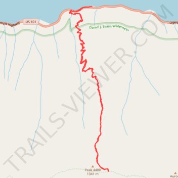
Aurora Creek Trail
- Distance: 7.1 mi
- Elevation gain: 3,921 ft
- Maximum elevation: 4,281 ft
- Elevation loss: 4,006 ft
- Minimum elevation: 568 ft
- Moving time: 4 h 21 m
- Moving speed: 1.6 mph
- Maximum speed: 5.2 mph
- Total time: 5 h 39 m
- Global speed: 1.3 mph
Interactive trail map
Trail profile
- Distance: 7.1 mi
- Elevation gain: 3,921 ft
- Maximum elevation: 4,281 ft
- Elevation loss: 4,006 ft
- Minimum elevation: 568 ft
- Moving time: 4 h 21 m
- Moving speed: 1.6 mph
- Maximum speed: 5.2 mph
- Total time: 5 h 39 m
- Global speed: 1.3 mph
About this trail
Name: Aurora Creek Trail trail, distance, elevation, map, profile, GPS track
Start: 225103, Olympic Highway, Clallam County, Washington, 98363, United States (48.05189 -123.83658)
End: Olympic Highway, Clallam County, Washington, United States (48.05202 -123.83414)
Coordinates: 48.02360 -123.84007 48.05208 -123.82989
Topography: Clallam County topographic map, elevation, terrain