Thank you for supporting this site ❤️
Make a donation
Make a donation
Gear up for your next adventure:
As an Amazon Associate, this site earns from qualifying purchases at no extra cost to you.
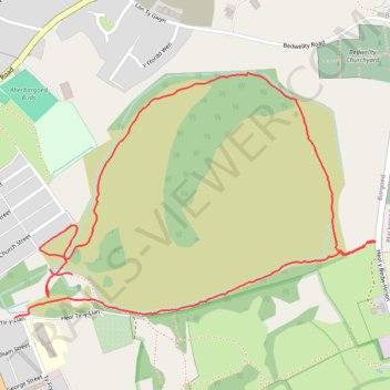
Aberbargoed old colliery paths
- Distance: 1.7 mi
- Elevation gain: 249 ft
- Maximum elevation: 968 ft
- Elevation loss: 282 ft
- Minimum elevation: 725 ft
- Moving time: 39 m 37 s
- Moving speed: 2.5 mph
- Maximum speed: 3.7 mph
- Total time: 39 m 37 s
- Global speed: 2.5 mph
Interactive trail map
Thank you for supporting this site ❤️
Make a donation
Make a donation
Gear up for your next adventure:
As an Amazon Associate, this site earns from qualifying purchases at no extra cost to you.
Trail profile
- Distance: 1.7 mi
- Elevation gain: 249 ft
- Maximum elevation: 968 ft
- Elevation loss: 282 ft
- Minimum elevation: 725 ft
- Moving time: 39 m 37 s
- Moving speed: 2.5 mph
- Maximum speed: 3.7 mph
- Total time: 39 m 37 s
- Global speed: 2.5 mph
Thank you for supporting this site ❤️
Make a donation
Make a donation
Gear up for your next adventure:
As an Amazon Associate, this site earns from qualifying purchases at no extra cost to you.
About this trail
Name: Aberbargoed old colliery paths trail, distance, elevation, map, profile, GPS track
Coordinates: 51.69021 -3.21997 51.69525 -3.20798
Thank you for supporting this site ❤️
Make a donation
Make a donation
Gear up for your next adventure:
As an Amazon Associate, this site earns from qualifying purchases at no extra cost to you.
Other hiking, mountain biking, running and outdoor activity trails
Click on a trail to view its statistics, map and profile.
The Headstock 500
United Kingdom > Wales > Newport > Newport
Distance: 300.4 mi • Elevation gain: 31,549 ft • Maximum elevation: 2,267 ft