Make a donation
Gear up for your next adventure:
As an Amazon Associate, this site earns from qualifying purchases at no extra cost to you.
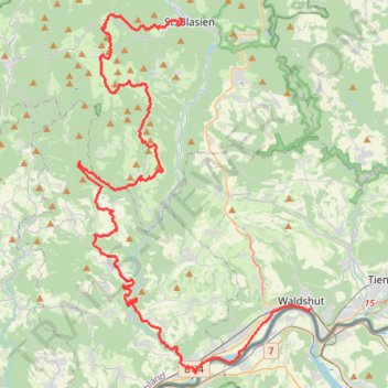
RouteWT 15 Streckentour
- Distance: 34.9 mi
- Elevation gain: 3,478 ft
- Maximum elevation: 3,458 ft
- Elevation loss: 4,879 ft
- Minimum elevation: 1,004 ft
Interactive trail map
Make a donation
Gear up for your next adventure:
As an Amazon Associate, this site earns from qualifying purchases at no extra cost to you.
Trail profile
- Distance: 34.9 mi
- Elevation gain: 3,478 ft
- Maximum elevation: 3,458 ft
- Elevation loss: 4,879 ft
- Minimum elevation: 1,004 ft
Make a donation
Gear up for your next adventure:
As an Amazon Associate, this site earns from qualifying purchases at no extra cost to you.
About this trail
Name: RouteWT 15 Streckentour trail, distance, elevation, map, profile, GPS track
Coordinates: 47.58913 8.05164 47.76368 8.21857
Make a donation
Gear up for your next adventure:
As an Amazon Associate, this site earns from qualifying purchases at no extra cost to you.
Other hiking, mountain biking, running and outdoor activity trails
Click on a trail to view its statistics, map and profile.
WT-BLA026 <-> WT-WAD046
Germany > Baden-Württemberg > Landkreis Waldshut > St. Blasien
Distance: 38.1 mi • Elevation gain: 3,852 ft • Maximum elevation: 3,757 ft
WT-BLA026 <-> WT-WAD044
Germany > Baden-Württemberg > Landkreis Waldshut > St. Blasien
Distance: 16.1 mi • Elevation gain: 1,280 ft • Maximum elevation: 3,314 ft
Track vom: 2020-06-13 07:00
Germany > North Rhine-Westphalia > Kreis Wesel > Schermbeck
Distance: 422.5 mi • Elevation gain: 17,392 ft • Maximum elevation: 3,022 ft
Track vom: 2020-06-27 07:26
Germany > Bavaria > Landkreis Ostallgäu > Halblech
Distance: 427.6 mi • Elevation gain: 14,131 ft • Maximum elevation: 2,989 ft
Make a donation
Gear up for your next adventure:
As an Amazon Associate, this site earns from qualifying purchases at no extra cost to you.
Riethoven naar Oostenrijk
Netherlands > North Brabant > Riethoven > Eind
Distance: 573.0 mi • Elevation gain: 44,715 ft • Maximum elevation: 6,224 ft
PT23BS1 Kiel → Lörrach
Germany > Schleswig-Holstein > Kiel
Distance: 650.4 mi • Elevation gain: 30,397 ft • Maximum elevation: 2,484 ft
RouteWT 16 Streckentour
Germany > Baden-Württemberg > Landkreis Waldshut > St. Blasien
Bequem mit dem Radbus Linie 7322 zwischen St. Blasie und Waldshut fahren: Alle Busse haben ab 2024 Heckträger für Räder.
Distance: 16.2 mi • Elevation gain: 1,362 ft • Maximum elevation: 3,314 ft
WT-BLA026 <-> WT-WAD046
Germany > Baden-Württemberg > Landkreis Waldshut > St. Blasien
Distance: 35.2 mi • Elevation gain: 3,379 ft • Maximum elevation: 3,458 ft
Make a donation
Gear up for your next adventure:
As an Amazon Associate, this site earns from qualifying purchases at no extra cost to you.
WT-BLA026 <-> WT-BLA018
Germany > Baden-Württemberg > Landkreis Waldshut > St. Blasien
Distance: 2.4 mi • Elevation gain: 390 ft • Maximum elevation: 2,690 ft