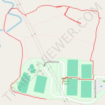
Blanchard Woods Park loop
- Distance: 1.8 mi
- Elevation gain: 131 ft
- Maximum elevation: 325 ft
- Elevation loss: 115 ft
- Minimum elevation: 210 ft
- Moving time: 41 m 13 s
- Moving speed: 2.6 mph
- Maximum speed: 4.2 mph
- Total time: 51 m 49 s
- Global speed: 2.1 mph
Interactive trail map
Trail profile
- Distance: 1.8 mi
- Elevation gain: 131 ft
- Maximum elevation: 325 ft
- Elevation loss: 115 ft
- Minimum elevation: 210 ft
- Moving time: 41 m 13 s
- Moving speed: 2.6 mph
- Maximum speed: 4.2 mph
- Total time: 51 m 49 s
- Global speed: 2.1 mph
About this trail
Name: Blanchard Woods Park loop trail, distance, elevation, map, profile, GPS track
Start: Blanchard Woods Drive, Columbia County, Georgia, 30809, United States (33.55311 -82.17579)
End: 4699, Blanchard Woods Drive, Columbia County, Georgia, 30809, United States (33.55400 -82.17462)
Coordinates: 33.55311 -82.17880 33.55871 -82.17187
Topography: Columbia County topographic map, elevation, terrain