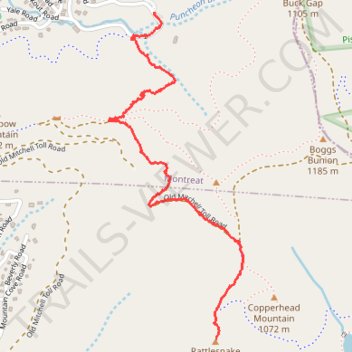
Rattlesnake Mountain Trail
- Distance: 1.6 mi
- Elevation gain: 666 ft
- Maximum elevation: 3,560 ft
- Elevation loss: 256 ft
- Minimum elevation: 2,986 ft
- Moving time: 39 m 39 s
- Moving speed: 2.5 mph
- Maximum speed: 5.3 mph
- Total time: 44 m 22 s
- Global speed: 2.2 mph
Interactive trail map
Trail profile
- Distance: 1.6 mi
- Elevation gain: 666 ft
- Maximum elevation: 3,560 ft
- Elevation loss: 256 ft
- Minimum elevation: 2,986 ft
- Moving time: 39 m 39 s
- Moving speed: 2.5 mph
- Maximum speed: 5.3 mph
- Total time: 44 m 22 s
- Global speed: 2.2 mph
About this trail
Name: Rattlesnake Mountain Trail trail, distance, elevation, map, profile, GPS track
Coordinates: 35.63127 -82.29196 35.64383 -82.28558
Topography: Buncombe County topographic map, elevation, terrain
Other hiking, mountain biking, running and outdoor activity trails
Click on a trail to view its statistics, map and profile.
Lookout Rocks via Lookout Trail
United States > North Carolina > Buncombe County > Montreat
Distance: 1.2 mi • Elevation gain: 486 ft • Maximum elevation: 3,478 ft
Lookout Rocks
United States > North Carolina > Buncombe County > Montreat
Distance: 1.5 mi • Elevation gain: 571 ft • Maximum elevation: 3,481 ft