Thank you for supporting this site ❤️
Make a donation
Make a donation
Gear up for your next adventure:
As an Amazon Associate, this site earns from qualifying purchases at no extra cost to you.
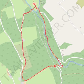
Galtee castle wood Purple
- Distance: 2.6 mi
- Elevation gain: 358 ft
- Maximum elevation: 935 ft
- Elevation loss: 449 ft
- Minimum elevation: 607 ft
- Moving time: 1 h 11 m
- Moving speed: 2.2 mph
- Maximum speed: 3.7 mph
- Total time: 1 h 16 m
- Global speed: 2.0 mph
Interactive trail map
Thank you for supporting this site ❤️
Make a donation
Make a donation
Gear up for your next adventure:
As an Amazon Associate, this site earns from qualifying purchases at no extra cost to you.
Trail profile
- Distance: 2.6 mi
- Elevation gain: 358 ft
- Maximum elevation: 935 ft
- Elevation loss: 449 ft
- Minimum elevation: 607 ft
- Moving time: 1 h 11 m
- Moving speed: 2.2 mph
- Maximum speed: 3.7 mph
- Total time: 1 h 16 m
- Global speed: 2.0 mph
Thank you for supporting this site ❤️
Make a donation
Make a donation
Gear up for your next adventure:
As an Amazon Associate, this site earns from qualifying purchases at no extra cost to you.
About this trail
Name: Galtee castle wood Purple trail, distance, elevation, map, profile, GPS track
Coordinates: 52.31883 -8.18726 52.33171 -8.17581
Thank you for supporting this site ❤️
Make a donation
Make a donation
Gear up for your next adventure:
As an Amazon Associate, this site earns from qualifying purchases at no extra cost to you.
Other hiking, mountain biking, running and outdoor activity trails
Click on a trail to view its statistics, map and profile.
Thurles - Cork
Ireland > County Tipperary > Thurles
#Bike
Distance: 80.6 mi • Elevation gain: 3,730 ft • Maximum elevation: 778 ft