Sandestin loop run
- Distance: 3.1 mi
- Elevation gain: 82 ft
- Maximum elevation: 52 ft
- Elevation loss: 82 ft
- Minimum elevation: 13 ft
- Moving time: 37 m 25 s
- Moving speed: 4.9 mph
- Maximum speed: 10.2 mph
- Total time: 37 m 25 s
- Global speed: 4.9 mph
Interactive trail map
Trail profile
- Distance: 3.1 mi
- Elevation gain: 82 ft
- Maximum elevation: 52 ft
- Elevation loss: 82 ft
- Minimum elevation: 13 ft
- Moving time: 37 m 25 s
- Moving speed: 4.9 mph
- Maximum speed: 10.2 mph
- Total time: 37 m 25 s
- Global speed: 4.9 mph
About this trail
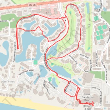
Name: Sandestin loop run trail, distance, elevation, map, profile, GPS track
Coordinates: 30.36956 -86.33445 30.37803 -86.32700
Topography: Walton County topographic map, elevation, terrain