Saddle Mountain Trail
The Saddle Mountain Trail offers a moderately strenuous hike with rewarding views as you ascend to the summit. Along the way, hikers are treated to expansive vistas of the Pacific Ocean, Cascade volcanoes, and the rugged Oregon Coast Range, with especially dramatic views from the summit. The trail is well-equipped with features like chain-link sections for traction on steep stretches and various handrails, though the climb can be challenging in parts, particularly in colder or wetter weather. #Hiking #Mountain #Forest #Nature #Overlook
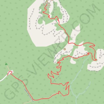
- Distance: 4.6 mi
- Elevation gain: 2,175 ft
- Maximum elevation: 3,196 ft
- Elevation loss: 2,172 ft
- Minimum elevation: 1,644 ft
Interactive trail map
Trail profile
- Distance: 4.6 mi
- Elevation gain: 2,175 ft
- Maximum elevation: 3,196 ft
- Elevation loss: 2,172 ft
- Minimum elevation: 1,644 ft
About this trail
Name: Saddle Mountain Trail trail, distance, elevation, map, profile, GPS track
End: Saddle Mountain Trail, Clatsop County, Oregon, United States (45.96273 -123.68990)
Coordinates: 45.96047 -123.69035 45.96882 -123.67917
Topography: Clatsop County topographic map, elevation, terrain