Burnt Lake Trail in Mount Hood National Forest
The Burnt Lake Trail in the Mount Hood Wilderness offers a well-rounded hiking experience with its combination of lush forests, rugged terrain, and panoramic views. As you ascend through moss-draped conifer forests, the trail leads to a pristine mountain lake where the striking silhouette of Mount Hood looms in the background, making the destination particularly stunning. The hike also offers opportunities to spot wildflowers, take a detour to a waterfall, and enjoy peaceful moments along the lake’s shoreline. #Hiking #Mountain #Forest #Nature #Lake
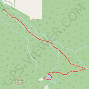
- Distance: 7.3 mi
- Elevation gain: 1,496 ft
- Maximum elevation: 4,163 ft
- Elevation loss: 1,483 ft
- Minimum elevation: 2,703 ft
Interactive trail map
Trail profile
- Distance: 7.3 mi
- Elevation gain: 1,496 ft
- Maximum elevation: 4,163 ft
- Elevation loss: 1,483 ft
- Minimum elevation: 2,703 ft
About this trail
Name: Burnt Lake Trail in Mount Hood National Forest trail, distance, elevation, map, profile, GPS track
Start: Burnt Lake Trail #772, Clackamas County, Oregon, United States (45.37200 -121.82236)
End: Burnt Lake Trail #772, Clackamas County, Oregon, United States (45.37164 -121.82180)
Coordinates: 45.35004 -121.82236 45.37200 -121.78596
Topography: Clackamas County topographic map, elevation, terrain
Other hiking, mountain biking, running and outdoor activity trails
Click on a trail to view its statistics, map and profile.
Northern part of the Pacific Crest Trail (PCT)
United States > Oregon > Klamath County
Hike on the Pacific Crest National Scenic Trail from Crater Lake to Canada Border through Oregon and Washington along the Sierra Nevada and Cascade mountain ranges. #Hiking #Mountain #SierraNevada #Cascade #Nature #Forest #Park #PCT
Distance: 744.6 mi • Elevation gain: 145,367 ft • Maximum elevation: 7,569 ft