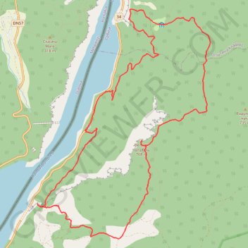
Miroč - Đerdap: Mali Prilaz - Veliki Štrbac - Ploča
- Distance: 9.8 mi
- Elevation gain: 3,018 ft
- Maximum elevation: 2,457 ft
- Elevation loss: 3,012 ft
- Minimum elevation: 276 ft
- Moving time: 5 h 47 m
- Moving speed: 1.7 mph
- Maximum speed: 7.4 mph
- Total time: 9 h 45 s
- Global speed: 1.1 mph
Interactive trail map
Trail profile
- Distance: 9.8 mi
- Elevation gain: 3,018 ft
- Maximum elevation: 2,457 ft
- Elevation loss: 3,012 ft
- Minimum elevation: 276 ft
- Moving time: 5 h 47 m
- Moving speed: 1.7 mph
- Maximum speed: 7.4 mph
- Total time: 9 h 45 s
- Global speed: 1.1 mph
About this trail
Name: Miroč - Đerdap: Mali Prilaz - Veliki Štrbac - Ploča trail, distance, elevation, map, profile, GPS track
Coordinates: 44.57718 22.25659 44.61297 22.29448
Other hiking, mountain biking, running and outdoor activity trails
Click on a trail to view its statistics, map and profile.
Miroč - Đerdap: Mali i Veliki Štrbac
Serbia > Central Serbia > Bor Administrative District > Kladovo Municipality > Tekija > Golo Brdo
Distance: 10.9 mi • Elevation gain: 2,513 ft • Maximum elevation: 2,457 ft