Thank you for supporting this site ❤️
Make a donation
Make a donation
Gear up for your next adventure:
As an Amazon Associate, this site earns from qualifying purchases at no extra cost to you.
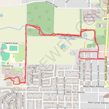
Western Portion of Searcy Bike Trail and Searcy High School
Evening Ride
- Distance: 4.0 mi
- Elevation gain: 138 ft
- Maximum elevation: 295 ft
- Elevation loss: 144 ft
- Minimum elevation: 220 ft
- Moving time: 31 m 31 s
- Moving speed: 7.5 mph
- Maximum speed: 17.5 mph
- Total time: 45 m 17 s
- Global speed: 5.2 mph
Interactive trail map
Thank you for supporting this site ❤️
Make a donation
Make a donation
Gear up for your next adventure:
As an Amazon Associate, this site earns from qualifying purchases at no extra cost to you.
Trail profile
- Distance: 4.0 mi
- Elevation gain: 138 ft
- Maximum elevation: 295 ft
- Elevation loss: 144 ft
- Minimum elevation: 220 ft
- Moving time: 31 m 31 s
- Moving speed: 7.5 mph
- Maximum speed: 17.5 mph
- Total time: 45 m 17 s
- Global speed: 5.2 mph
Thank you for supporting this site ❤️
Make a donation
Make a donation
Gear up for your next adventure:
As an Amazon Associate, this site earns from qualifying purchases at no extra cost to you.
About this trail
Name: Western Portion of Searcy Bike Trail and Searcy High School trail, distance, elevation, map, profile, GPS track
Coordinates: 35.25113 -91.76127 35.25884 -91.74532
Topography: White County topographic map, elevation, terrain
Thank you for supporting this site ❤️
Make a donation
Make a donation
Gear up for your next adventure:
As an Amazon Associate, this site earns from qualifying purchases at no extra cost to you.