Diamond Hill
Connemara National Park. #Hiking #Loop #DiamondHill #Connemara
- Distance: 4.4 mi
- Elevation gain: 1,299 ft
- Maximum elevation: 1,427 ft
- Elevation loss: 1,289 ft
- Minimum elevation: 174 ft
- Moving time: 2 h 6 s
- Moving speed: 2.2 mph
- Maximum speed: 4.6 mph
- Total time: 2 h 29 m
- Global speed: 1.8 mph
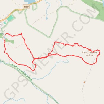
Interactive trail map
Trail profile
- Distance: 4.4 mi
- Elevation gain: 1,299 ft
- Maximum elevation: 1,427 ft
- Elevation loss: 1,289 ft
- Minimum elevation: 174 ft
- Moving time: 2 h 6 s
- Moving speed: 2.2 mph
- Maximum speed: 4.6 mph
- Total time: 2 h 29 m
- Global speed: 1.8 mph
About this trail
Name: Diamond Hill trail, distance, elevation, map, profile, GPS track
Coordinates: 53.54377 -9.94498 53.55180 -9.91085