Make a donation
Gear up for your next adventure:
As an Amazon Associate, this site earns from qualifying purchases at no extra cost to you.
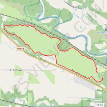
Minneopa State Park
Minneola State Park, Seppmann mill trail
- Distance: 5.1 mi
- Elevation gain: 213 ft
- Maximum elevation: 896 ft
- Elevation loss: 220 ft
- Minimum elevation: 823 ft
- Moving time: 2 h 13 m
- Moving speed: 2.3 mph
- Maximum speed: 3.4 mph
- Total time: 2 h 41 m
- Global speed: 1.9 mph
Interactive trail map
Make a donation
Gear up for your next adventure:
As an Amazon Associate, this site earns from qualifying purchases at no extra cost to you.
Trail profile
- Distance: 5.1 mi
- Elevation gain: 213 ft
- Maximum elevation: 896 ft
- Elevation loss: 220 ft
- Minimum elevation: 823 ft
- Moving time: 2 h 13 m
- Moving speed: 2.3 mph
- Maximum speed: 3.4 mph
- Total time: 2 h 41 m
- Global speed: 1.9 mph
Make a donation
Gear up for your next adventure:
As an Amazon Associate, this site earns from qualifying purchases at no extra cost to you.
About this trail
Name: Minneopa State Park trail, distance, elevation, map, profile, GPS track
Start: Seppmann Mill Trail, Blue Earth County, Minnesota, United States (44.15855 -94.08815)
End: Wetland Loop Trail, Blue Earth County, Minnesota, United States (44.15731 -94.08625)
Coordinates: 44.15591 -94.12298 44.17120 -94.08625
Topography: Blue Earth County topographic map, elevation, terrain
Make a donation
Gear up for your next adventure:
As an Amazon Associate, this site earns from qualifying purchases at no extra cost to you.