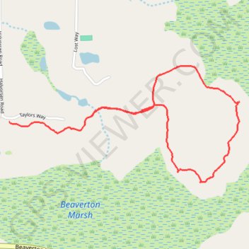
Beaverton Marsh Loop (San Juan Island)
Loop hike above Beaverton Marsh via Nuhatch Trail, Dragonfly Loop Trail and Pintail Trail on the San Juan Island. #Hiking #Loop #Nature #Forest
- Distance: 2.0 mi
- Elevation gain: 213 ft
- Maximum elevation: 177 ft
- Elevation loss: 190 ft
- Minimum elevation: 95 ft
- Moving time: 1 h 2 m
- Moving speed: 1.9 mph
- Maximum speed: 3.0 mph
- Total time: 1 h 11 m
- Global speed: 1.6 mph
Interactive trail map
Trail profile
- Distance: 2.0 mi
- Elevation gain: 213 ft
- Maximum elevation: 177 ft
- Elevation loss: 190 ft
- Minimum elevation: 95 ft
- Moving time: 1 h 2 m
- Moving speed: 1.9 mph
- Maximum speed: 3.0 mph
- Total time: 1 h 11 m
- Global speed: 1.6 mph
About this trail
Name: Beaverton Marsh Loop (San Juan Island) trail, distance, elevation, map, profile, GPS track
Start: Nuthatch Trail, San Juan County, Washington, 98250, United States (48.54664 -123.04918)
End: Nuthatch Trail, San Juan County, Washington, 98250, United States (48.54640 -123.05508)
Coordinates: 48.54349 -123.05508 48.54910 -123.03838
Topography: San Juan County topographic map, elevation, terrain
Other hiking, mountain biking, running and outdoor activity trails
Click on a trail to view its statistics, map and profile.