Thank you for supporting this site ❤️
Make a donation
Make a donation
Gear up for your next adventure:
As an Amazon Associate, this site earns from qualifying purchases at no extra cost to you.
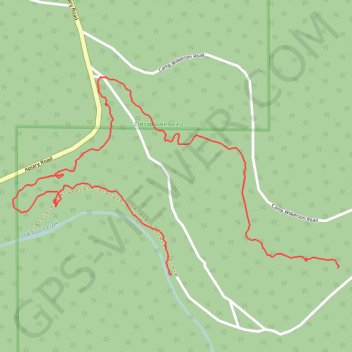
Paths in Camp Wilkerson
- Distance: 1.8 mi
- Elevation gain: 187 ft
- Maximum elevation: 1,316 ft
- Elevation loss: 285 ft
- Minimum elevation: 1,145 ft
- Moving time: 40 m 20 s
- Moving speed: 2.7 mph
- Maximum speed: 13.1 mph
- Total time: 42 m 43 s
- Global speed: 2.5 mph
Interactive trail map
Thank you for supporting this site ❤️
Make a donation
Make a donation
Gear up for your next adventure:
As an Amazon Associate, this site earns from qualifying purchases at no extra cost to you.
Trail profile
- Distance: 1.8 mi
- Elevation gain: 187 ft
- Maximum elevation: 1,316 ft
- Elevation loss: 285 ft
- Minimum elevation: 1,145 ft
- Moving time: 40 m 20 s
- Moving speed: 2.7 mph
- Maximum speed: 13.1 mph
- Total time: 42 m 43 s
- Global speed: 2.5 mph
Thank you for supporting this site ❤️
Make a donation
Make a donation
Gear up for your next adventure:
As an Amazon Associate, this site earns from qualifying purchases at no extra cost to you.
About this trail
Name: Paths in Camp Wilkerson trail, distance, elevation, map, profile, GPS track
Start: Columbia County, Oregon, United States (45.92757 -123.04938)
End: Camp Wilkerson Road, Columbia County, Oregon, United States (45.92737 -123.05614)
Coordinates: 45.92737 -123.06260 45.93298 -123.04933
Topography: Columbia County topographic map, elevation, terrain
Thank you for supporting this site ❤️
Make a donation
Make a donation
Gear up for your next adventure:
As an Amazon Associate, this site earns from qualifying purchases at no extra cost to you.