Make a donation
Gear up for your next adventure:
As an Amazon Associate, this site earns from qualifying purchases at no extra cost to you.
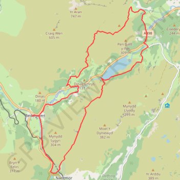
Nantgwynant, Gwynedd - Red Dragon, White Dragon
A circular walks with wonderful views on clearly defined paths along rivers, woods and some exposed hillsides. Parts may be boggy and muddy at times with rock sections that can be slippery if wet. There are options to shorten the walk.
- Distance: 10.6 mi
- Elevation gain: 2,146 ft
- Maximum elevation: 1,066 ft
- Elevation loss: 2,146 ft
- Minimum elevation: 92 ft
Interactive trail map
Make a donation
Gear up for your next adventure:
As an Amazon Associate, this site earns from qualifying purchases at no extra cost to you.
Trail profile
- Distance: 10.6 mi
- Elevation gain: 2,146 ft
- Maximum elevation: 1,066 ft
- Elevation loss: 2,146 ft
- Minimum elevation: 92 ft
Make a donation
Gear up for your next adventure:
As an Amazon Associate, this site earns from qualifying purchases at no extra cost to you.
About this trail
Name: Nantgwynant, Gwynedd - Red Dragon, White Dragon trail, distance, elevation, map, profile, GPS track
Start: A498, Beddgelert, Gwynedd, Wales, LL55 4YQ, United Kingdom (53.01147 -4.10418)
End: A498, Beddgelert, Gwynedd, Wales, LL55 4YQ, United Kingdom (53.01148 -4.10417)
Coordinates: 52.99483 -4.10418 53.04318 -4.04815
Make a donation
Gear up for your next adventure:
As an Amazon Associate, this site earns from qualifying purchases at no extra cost to you.
Other hiking, mountain biking, running and outdoor activity trails
Click on a trail to view its statistics, map and profile.
Aberglaslyn towards Cae Coch - thwarted due to too much vegetation
United Kingdom > Wales > Gwynedd > Nantmor
Gwynedd Walking
Distance: 4.9 mi • Elevation gain: 1,273 ft • Maximum elevation: 702 ft
Beddgelert, Llyn Dinas, Blaen Nanmor and Nantmor circuit
United Kingdom > Wales > Gwynedd > Beddgelert
Distance: 9.4 mi • Elevation gain: 1,289 ft • Maximum elevation: 597 ft
Ultra-Trail Snowdonia Eryri UTS 100M
United Kingdom > Wales > Gwynedd > Llanberis
Distance: 101.4 mi • Elevation gain: 31,837 ft • Maximum elevation: 3,471 ft
Walk to Dinas Emrys
United Kingdom > Wales > Gwynedd > Beddgelert
Distance: 2.3 mi • Elevation gain: 466 ft • Maximum elevation: 384 ft
Make a donation
Gear up for your next adventure:
As an Amazon Associate, this site earns from qualifying purchases at no extra cost to you.