Thank you for supporting this site ❤️
Make a donation
Make a donation
Gear up for your next adventure:
As an Amazon Associate, this site earns from qualifying purchases at no extra cost to you.
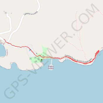
Area Recreativa Playita Rosada
- Distance: 0.7 mi
- Elevation gain: 36 ft
- Maximum elevation: 43 ft
- Elevation loss: 46 ft
- Minimum elevation: 7 ft
- Moving time: 17 m 33 s
- Moving speed: 2.5 mph
- Maximum speed: 18.5 mph
- Total time: 20 m 37 s
- Global speed: 2.1 mph
Interactive trail map
Thank you for supporting this site ❤️
Make a donation
Make a donation
Gear up for your next adventure:
As an Amazon Associate, this site earns from qualifying purchases at no extra cost to you.
Trail profile
- Distance: 0.7 mi
- Elevation gain: 36 ft
- Maximum elevation: 43 ft
- Elevation loss: 46 ft
- Minimum elevation: 7 ft
- Moving time: 17 m 33 s
- Moving speed: 2.5 mph
- Maximum speed: 18.5 mph
- Total time: 20 m 37 s
- Global speed: 2.1 mph
Thank you for supporting this site ❤️
Make a donation
Make a donation
Gear up for your next adventure:
As an Amazon Associate, this site earns from qualifying purchases at no extra cost to you.
About this trail
Name: Area Recreativa Playita Rosada trail, distance, elevation, map, profile, GPS track
Coordinates: 17.97181 -67.03452 17.97333 -67.02840
Topography: Lajas topographic map, elevation, terrain
Thank you for supporting this site ❤️
Make a donation
Make a donation
Gear up for your next adventure:
As an Amazon Associate, this site earns from qualifying purchases at no extra cost to you.